How To View Your Farm Map Online?
A map is a land format that certifies your property’s boundaries. Every person should have a map of their farm and property so that they do not get duped. If you’d like to get a map of your farm, the government has made the entire process available online.
Previously, obtaining a map of a farm or any land required a visit to various offices. Today, you can view the map of your farm online. If you’re wondering how to see your farm’s map online, we’ll walk you through some simple steps.
What Is Required To View Farm Map Online?
To view a farm map online, typically you would need the following:
- Access to the Internet: A stable internet connection is essential to access online portals or websites where farm maps are available.
- Device: You can use a computer, laptop, tablet, or smartphone to access the online portal.
- Specific Website: Depending on your location (state or region), you may need to visit a specific government-run website or portal that hosts farm maps. For example, in Uttar Pradesh, you might visit the BHU NAKSHA portal or similar state-specific portals.
- Location Details: You should know the specific details of the farm’s location, such as the district, tehsil (sub-district), and village name.
- Identification Numbers: To pinpoint a specific farm, you might need identification numbers such as the Khasra number (plot number) and Khatauni number (land record number). These help in accurately locating the farm on the map.
- Understanding of the Interface: Familiarity with navigating the online interface of the portal is helpful. Look for options like “Show Farm Map” or similar to access the detailed view of the farm.
By having these essentials ready, you can efficiently access and view farm maps online, gaining valuable insights into land boundaries, ownership details, and other relevant information.
How To View Farm Map Online?
To view a farm map online, follow these steps:
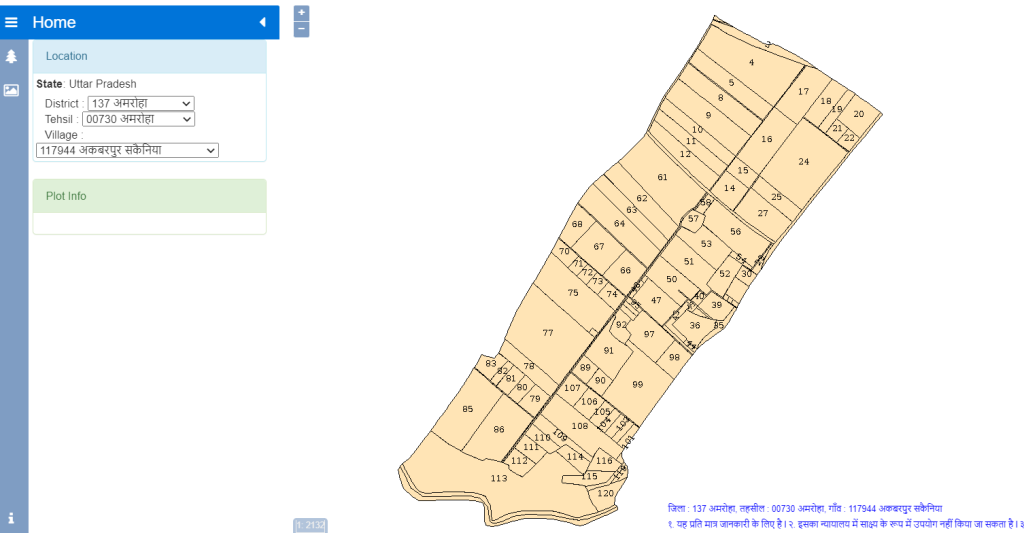
- Access the Official Website: Visit the official website of the land records or mapping authority for your state or region. For example, in Uttar Pradesh, you would visit the BHU NAKSHA portal (https://upbhunaksha.gov.in/) operated by the state government.
- Select Your Location: On the homepage of the website, select your district from the provided list. This narrows down the search to your specific area of interest.
- Choose Tehsil/Sub-District: After selecting the district, choose the tehsil or sub-district where the farm is located. This further refines the search to your local administrative area.
- Identify Your Village: Once the tehsil is selected, choose the village or locality where the farm is situated. This step helps in pinpointing the exact location within the administrative boundary.
- Navigate to Land Maps: Look for options such as “View Land Maps,” “Show Map Details,” or similar. Click on these options to proceed to the next stage where you can view detailed maps of the land parcels.
- Enter Specific Details (Optional): If required, enter specific details such as the Khasra number (plot number) or Khatauni number (land record number) to directly access the map of a particular farm. These details help in precise identification and mapping.
- View the Farm Map: Once you have selected the appropriate options and entered any necessary details, the farm map should be displayed on your screen. You can view boundaries, land divisions, and other relevant details directly on the map.
- Navigation and Features: Explore the map using navigation tools provided on the website. You can zoom in or out, pan across the map, and use tools to measure distances or areas if available.
- Save or Print (Optional): If needed, you can save the map or print it for future reference. This can be useful for documentation purposes or sharing information with relevant parties.
By following these steps, you can easily access and view farm maps online, gaining valuable insights into the geographical layout and details of agricultural land in your area.
How To View Farm Map Offline?
Viewing a farm map offline typically involves accessing and downloading the map data onto your device for later viewing when you’re not connected to the internet. Here’s how you can view a farm map offline:
- Download Map Data: Before going offline, ensure you have downloaded the necessary map data onto your device. This usually involves using a mapping application or service that allows offline map access. Some platforms like Google Maps or specialized GIS (Geographic Information System) apps offer offline map download options.
- Use Mapping Apps: Choose a mapping application that supports offline map viewing. Apps like Google Maps, MAPS.ME, or specialized GIS apps like QGIS or ArcGIS Collector allow you to download maps for offline use. These apps often have specific instructions for downloading maps offline, which typically involve selecting an area or region to download.
- Select Area for Offline Use: Open the mapping app and navigate to the area where your farm is located. Use the app’s tools to select and download the map data for offline use. This ensures that the map and its details are stored locally on your device.
- Access Offline Maps: Once the map data is downloaded, you can access it anytime offline. Open the mapping app and switch to offline mode if necessary. You should be able to view the farm map with all its details, including boundaries, land divisions, and other features.
- Navigation and Features: While viewing the map offline, you can still use basic navigation features such as zooming in or out, panning across the map, and checking specific details like property boundaries. Note that some advanced features may require an internet connection to function.
- Update Map Data (Optional): Periodically update your offline map data to ensure you have the latest information. This is especially important if there have been changes to land boundaries or other features that affect your farm map.
By following these steps, you can view farm maps offline using various mapping applications that support offline mode. This method allows you to access critical farm map information even in areas with limited or no internet connectivity.
Benefits Of Viewing Farm Map
Viewing a farm map offers several benefits that can aid farmers, landowners, and agricultural professionals in managing their land effectively and making informed decisions. Here are some key benefits of viewing a farm map:
- Land Planning and Management:
- Boundary Identification: Helps in clearly delineating property boundaries, which is crucial for land management, fencing, and avoiding disputes.
- Parcel Identification: Enables farmers to identify different parcels of land, making it easier to manage crops, livestock, and infrastructure on specific sections of the farm.
- Precision Farming:
- Site-specific Management: Allows for precision farming techniques where agricultural practices are tailored to specific areas of the farm based on soil type, topography, and other factors.
- Resource Optimization: Helps in optimizing the use of resources such as water, fertilizers, and pesticides by applying them only where needed, thereby reducing costs and environmental impact.
- Infrastructure Planning:
- Farm Infrastructure: Facilitates planning and placement of farm infrastructure such as barns, irrigation systems, roads, and drainage systems based on the farm’s layout and topography.
- Access Routes: Provides clarity on access routes and pathways within the farm, ensuring efficient movement of machinery and personnel.
- Crop Rotation and Diversification:
- Field Mapping: Allows farmers to map out different fields and track crop rotations and diversification efforts over time, promoting soil health and pest management.
- Harvest Planning: Helps in planning harvest schedules and logistics by knowing the layout of fields and their access points.
- Regulatory Compliance and Documentation:
- Legal Compliance: Supports compliance with local regulations by accurately documenting land use, boundaries, and conservation practices.
- Records Management: Acts as a visual aid for maintaining records of land improvements, conservation efforts, and historical land use changes.
- Risk Management:
- Emergency Planning: Assists in emergency planning by identifying potential hazards, access points, and evacuation routes within the farm.
- Insurance and Claims: Provides accurate documentation for insurance purposes and facilitates claims processing in case of crop damage or other emergencies.
- Collaboration and Communication:
- Stakeholder Engagement: Enhances communication with stakeholders such as farm managers, employees, suppliers, and consultants by providing a clear visual representation of the farm layout and operations.
- Decision Making: Supports informed decision-making processes related to investments, land acquisitions, and farm expansion by visualizing the farm’s potential and limitations.
Overall, viewing a farm map is essential for efficient farm management, optimizing resources, complying with regulations, and making strategic decisions that contribute to the sustainability and profitability of agricultural operations.
Where To Complain If There Is Any Problem With Farm Land?
If your farmland is illegally occupied or you’re facing threats regarding your land, there are steps you can take to protect your rights:
- File a Police Complaint:
- Visit the nearest police station and file a written complaint against the person illegally occupying or threatening you regarding your land.
- Provide details of the situation and any evidence you have to support your claim.
- The police will investigate the matter and take necessary legal action against the accused.
- Approach Tehsildar or SDM:
- If you don’t receive adequate assistance from the police, approach the Tehsildar (revenue officer) or contact the Sub-Divisional Magistrate (SDM) directly.
- These officials oversee all land-related matters in your area and maintain records of land ownership.
- Present your case with all relevant documents and evidence to substantiate your claim.
- If your claim is verified and found valid, the Tehsildar or SDM will initiate appropriate actions to resolve the issue and ensure justice.
- Legal Support:
- Consider seeking legal advice or assistance from a lawyer specializing in property disputes.
- Legal experts can provide guidance on your rights, help draft legal documents, and represent you in legal proceedings if required.
- Documentation:
- Keep all documents related to your land, including ownership deeds, lease agreements, and any correspondence with authorities or individuals involved.
- These documents will serve as crucial evidence to support your claim and protect your rights.
- Follow-Up:
- Regularly follow up with the police or the revenue authorities to ensure that your complaint is actively pursued and resolved.
- Stay informed about the progress of your case and cooperate with authorities as needed to facilitate a speedy resolution.
By taking these steps promptly and following through with appropriate authorities, you can protect your land rights and seek justice against any illegal occupation or threats.
Conclusion
You learned how to see the map of your farm from the article above, and all of this information was shared with you in simple and clear language. We hope you understand everything about this article.